
I receive a lot of messages from my readers/subscribers noting that they would love to do POTA or SOTA activations, but either 1) park entities are too far away/inaccessible, or 2) physical health challenges limit them from engaging in summit activations.
In this article, I’d like to show you that by digging a little deeper into park boundaries and summit offerings in your area, you might be surprised how accessible both may be!
Moreover, this may be true even for those with some health or mobility limitations. Depending upon what they are (and always with your doctor’s approval, of course), you may be able to get “out in the field” at some parks, after all.
Let’s start this discussion by taking a deeper dive into our parks.
POTA Boundaries
Parks On The Air (POTA) has simply exploded in popularity in the past few years, and the volunteers who develop and administer the POTA program do an exemplary job.
POTA even has an amazing interactive map that will help you find parks where you live and where you travel. Simply open the POTA map tool, select your location, and look at all of the park offerings by clicking on each yellow GPS dot.
Here’s what the POTA map looks like for western North Carolina, as an example:
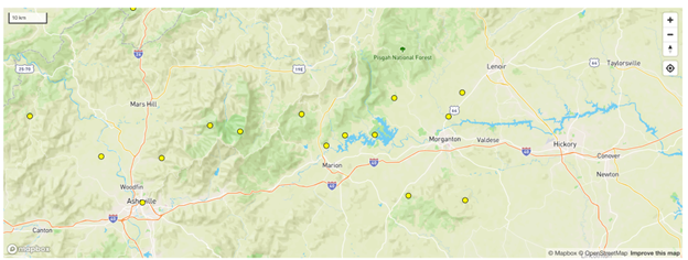
Note that each park entity is represented by one yellow pin dot.
There are a few potential shortcomings with this pin dot system. If you’re looking for the location of a building, pinpoints are superb. But state, provincial, and national parks–along with a wide array of other public lands–tend to be vast tracts of land with multiple access points. When only pinpoints are provided but no boundary markers are shown to give you a rough outline of the park, it’s not really possible to identify all potential points of access.
Indeed, POTA entities like trail and parkway systems can stretch over multiple counties or even multiple states/provinces. The Appalachian Trail and Blue Ridge Parkway, for example, may only be represented by one yellow dot per state, even though they’re hundreds of miles long, crossing state lines and numerous counties.
Game lands, forests, and recreational areas are often made up of multiple separate tracts of land instead of one contiguous chunk. Obviously, at first blush, those yellow dots can be misleading.
So, why doesn’t the POTA map show actual site boundaries? Keep in mind that POTA is an international program. POTA developers are clear that they can’t realistically project a map with actual site boundaries. That would require not only a massive amount of data collected from multiple sources in multiple countries, but it would also require fairly constant maintenance as boundaries shift and even as weather events (like rock falls or icing on roads in winter) occur. Even then, the maps still might not be 100% accurate.
Because of this, sorting out park boundaries is truly the responsibility of the POTA activator. Frankly, I think this is the way it should be. Indeed, I actually enjoy the detective work and the research required to scout out entries into parks…and you may find that you enjoy it, too.
What exactly constitutes a POTA entity varies by country. As an example, let’s take a look at a region I know well.
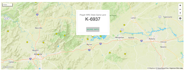
One of my earlier POTA activations was in Pisgah Game Lands WRC (K-6937). On the POTA map, it shows up as one yellow dot in western North Carolina:
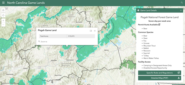
But game lands can be vast. To get a better idea of where the game land boundaries are, most states have dedicated mapping sites for public lands and game lands. In North Carolina, they have a fantastic site through the Wildlife Resource Commission for exploring game land boundaries. Here’s what it shows for Pisgah Game Lands. Note that the light blue outline shows all Pisgah Game Land tracts, representing over 515,000 acres throughout the entirety of the western portion of the state:
Game lands, however, are just one example. No matter where you live, there are almost always detailed maps of public lands online, in print, or even at a library or park office; all you need to do is explore the boundaries and seek access and parking points. And for those with mobility limitations who can drive, finding level entry points or even parking within the boundaries may give you an opportunity to activate with a minimum of physical activity.
Trails are often easier to find due to the number of maps available both in paper form and through sites and apps like AllTrails, which I use regularly. Parking and trailheads are marked clearly, which makes access and directions that much easier. Plus, you can read other hiker reviews which include field notes and tips about the terrain.
By doing this type of investigation, I’ve also discovered portions of parks with overlapping boundaries. In the POTA network, these are called “two-fers,” “three-fers,” and the like, suggesting that one can activate more than one park in one go (e.g., “two-fer” = two for one). Through a little research, I discovered a “two-fer” site within hiking distance of my own QTH! It’s likely I wouldn’t have found this site by referencing the POTA map only.
What have I learned from all of this? That the official POTA map is simply the starting point in your research!
Speaking of apps…
Since there are no POTA police to check up on you, keep in mind that it’s up to the activator to confirm when they are within park boundaries. But we all want to play fair. Indeed, we activators take pride in making sure that we’re playing by the POTA rules, so accuracy is important to us.
One app that I’ve found incredibly useful–especially for U.S. park entities which can cover vast tracts of land and which often seem to have ambiguous boundaries–is called Parceled:
The Parceled app is iOS only (only works with Apple products), but the Google Play store has numerous similar apps. One of the highest rated is Acres.co.
These apps not only allow you to research land ownership in advance, but also let you drive to the site and confirm on-the-spot that an adjacent parcel is, indeed, on public land.
Both of these apps are designed for real estate professionals—not POTA activators—so they include a lot of data that may not be useful or relevant to amateur radio operators. The most important information for activators is the name of the parcel owner: if it’s on public land, it will be in the name of the conservation organization, municipality, state, province, or other government entity, and therefore suitable to activate.
Google Maps
I also use Google Maps primarily to find directions to a site and to identify potential parking spots via the satellite view.
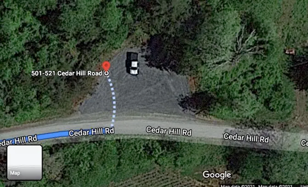
After I’ve done my in-depth research to identify park boundaries and access roads, I then overlay my findings over a Google Map, often identifying coordinates using, for instance, the shape of the road. Here’s one example I found in which the road shape matches what I found on the WRC mapping site:
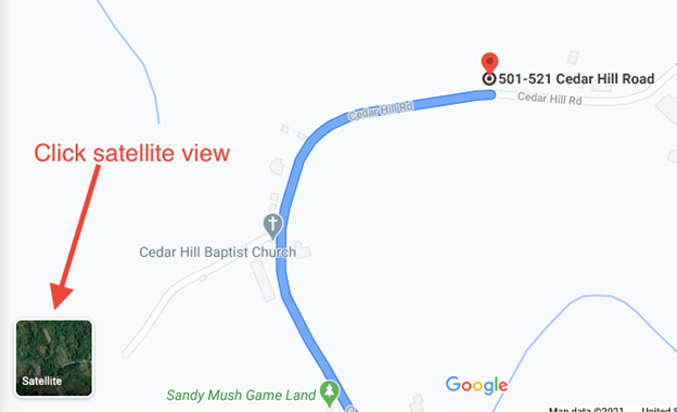
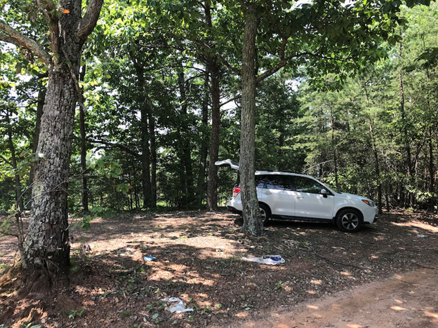
After clicking on Satellite view, I’m able to see a bird’s eye view of the area:
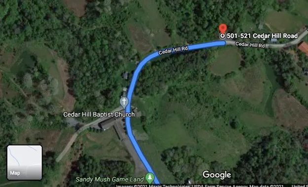
When I zoom in, I can identify a nice parking spot:
All I have to do then is grab the GPS coordinates and use my favorite navigation application to get the driving directions.
Over time, you’ll become quite proficient with this type of map research.
Google Maps is an incredible tool, but I wouldn’t use it to identifypark boundaries unless it is the only source. In my experience, their park boundaries (represented as shaded areas) can be inaccurate.
SOTA: Finding “Drive-Up” Summits
When we read field reports from Summits On The Air (SOTA) activators, they often mention seriously long hikes, fickle weather, and challenging conditions for setting up a field station. It’s certainly a reality, and I speak from experience on this point.
That said, not all SOTA activations look like climbing K2. In fact, there are often lots of “drive-up” SOTA summits in each SOTA region.
Drive-ups are summit sites where you can literally drive your car into, or at least very close to, the Activation Zone (AZ), which opens the door to activators with physical mobility limitations.
Keep in mind that in SOTA, you don’t have to be positioned on the true summit for a valid activation. The SOTA Activation Zone extends 25 vertical meters below the true summit. On rounded or flat summits, this can be a large activation area. If you’re uncertain where the SOTA AZ might be, check out N6ARA’s SOTA Activation Zone visualizer for guidance.
So, how do you find drive-up summits?
The SOTA site has a dedicated mapping page that shows all of the summits in the system along with links to site notes. Personally, I prefer using the more intuitive (especially for newcomers) SOTL.AS site for identifying summits and reading notes from the SOTA database.
Simply click on the summit and read the activator notes pages. These notes make it very easy to identify drive-up summits. Field notes from a drive-up summit typically start with a direct statement such as, “this is a drive-up summit.” It’s that easy. Of course, this requires clicking on each potential summit and reading the notes.
But I offer another, perhaps even better, way to discover drive-up summits below…
SOTA is Not Mobile
An important point to keep in mind: SOTA operations can only be a portable activity, meaning activations cannot be made inside your vehicle, nor can you activate from a permanent station (say, in the shack of a fellow ham who happens to live within an Activation Zone).
Drive-up SOTA activations only require that you fully set up your station away from your vehicle and not use it in any way to support the antenna, radio, or any other field components. When I activate a drive-up summit, I typically set up my station a minimum of 10-20 meters away from my car if the site allows.
Again, there are no SOTA police who monitor how or where you activate, but as we’re all in SOTA (and POTA) together for the spirit of it, we choose to follow the rules. Else, what would be the point? As always in our hobby, the honor system motivates adherence to good sportsmanship and a real appreciation for the challenges involved.
Community Connections
Whether you’re interested in POTA or SOTA, I can’t stress how important it is to connect with other activators in your community!
I remember when I first started exploring the world of SOTA. I spent days identifying local summits that I could potentially activate, say, in the span of one morning. During Field Day one year, I ran into a prolific SOTA activator and asked his advice. Within five minutes, he rattled off a list of at least a dozen SOTA sites that fit my description…so useful, and I was grateful for the tips.
Likewise, many regional SOTA and POTA operators belong to email discussion groups which are exceedingly helpful. This makes it easy to connect with other experienced activators to discover some of the best locations to activate, including those which might fit your needs if your mobility is limited. Many of these groups also have periodic in-person meetups.
I belong to a W4 SOTA discussion group, and recently one of our members created a map of all of the known drive-up summits. This is an incredibly useful resource for those who might not be able to physically hike long distances.
In a POTA discussion group last year, one activator with disabilities shared all of the parks he’d personally activated that had wheelchair-accessible picnic tables with space to set up a field station.
Groups are also a great space to find someone who can join you on an activation (a superb idea, particularly if you’re hiking a long distance in a remote area).
Safety Tips
It goes without saying that you should make sure that you’re not trespassing on private property in order to obtain access to public lands or summits. Both POTA and SOTA do not allow trespassing in any way shape or form in order to activate a site.
That said, if you have the property owner’s permission, you’re golden.
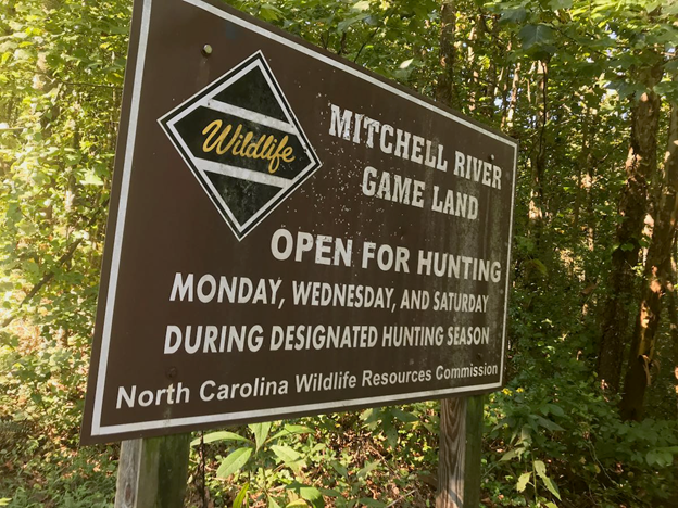
When entering any areas that allow hunting, make sure you’re wearing high-visibility attire. Many such game lands may specifically mention times when anyone other than hunters are not allowed on the property.
Also, if you are planning to operate in a remote region, let someone know where you are and what your itinerary will be.
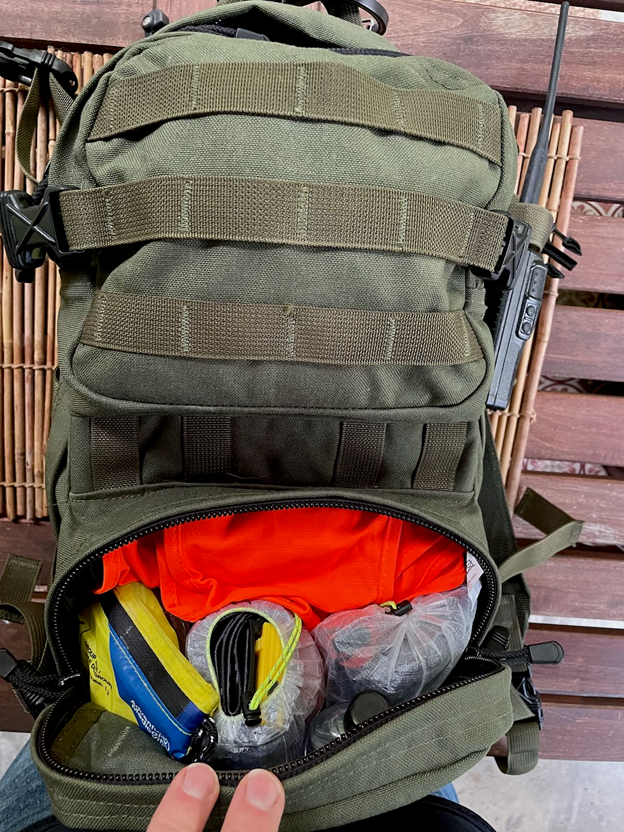
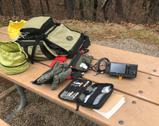
Of course, always carry a first aid kit and some basic emergency supplies. I not only keep a full IFAK (Individual First Aid Kit) in my vehicle, but I also have one in my field radio pack.
Saving and Organizing Your Research
In closing, I would strongly suggest that you tuck away and organize any in-depth research you’ve used to find activation sites. In the case of SOTA, consider sharing your information in the “activator notes” section for each summit.
Since the beginning of my POTA adventures, I’ve kept a Google spreadsheet with all of the POTA entities that have required research.
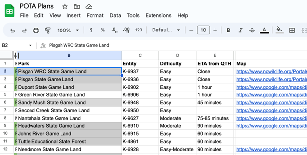
In each park entry on the sheet, I link to the GPS coordinates for the best activation sites and note any other helpful information. I keep a list of sites I’ve activated and ones I plan to activate.
Not only has this spreadsheet come in handy when I decide to visit an off-the-beaten-path POTA site I haven’t activated in a few years, but more often than not I have this information available to share with other activators who seek information and suggestions.
In fact, I’ve been contacted numerous times about some of the more remote and inaccessible sites I activated as ATNOs. Activators will see that I was the first person to activate the site, and they’ll often email asking for advice. It’s rewarding to be able to share my field notes with others when I can.
Accessible POTA and SOTA
I’ll never forget two years ago when a POTA activator in North Carolina complained that he didn’t have a POTA site within easy driving distance of his QTH. He and I performed the site research mentioned above and found that at least one POTA entity–a trail network–passed within a five-minute drive of his QTH. He also discovered three other POTA site access points within a 25-minute drive of his home. Wonderful!
If there’s just one message I would like to get across, it’s this: POTA and SOTA programs may be accessible to activators of even modest mobility levels who can safely operate a vehicle, so long as they’re willing to cast their nets a little wider by 1) doing some research online, 2) reaching out to the POTA and SOTA communities, and 3) speaking with park staff, if needed. And that’s great news for the POTA and SOTA programs, as well as those who wish to participate in them.
What’s your experience tracking POTA and SOTA sites been like? Please share your thoughts, hints, and tips in the comments section!