For those interested in satellite operating, the current climate of low-earth orbit (LEO) “birds” offers the chance to pursue contacts within a good-sized coverage area. Most operators are content to collect domestic awards such as ARRL’s Worked All States or the VHF/UHF Century Club (VUCC) award for collecting grid squares. But there are much greater possibilities to explore; there’s the opportunity to work real DX on the ham radio satellites, even on the LEO satellites. It takes a bit more patience and skill to pull off the long-haul contacts, but the rewards are worth it.
This blog post assumes you have some experience making satellite contacts. For an introduction to satellite operating, watch my video series on the DX Engineering YouTube channel.
Understanding the Footprint
All satellites have a footprint, which is the area the satellite covers at any given moment in time. As the satellite passes overhead, the footprint also changes constantly. Relative to your operating location, stations audible at the beginning of a pass may fade out of the footprint, while stations not in the footprint at the beginning of a pass may become audible near the end of your pass.
The area of coverage of a footprint varies from satellite to satellite, depending on how high in orbit a satellite is. While satellites that pass overhead are generally the easiest to access, the area of coverage is smaller during high-altitude passes. Maximum satellite distance occurs when passes are lower to your horizon, when your position is at the edge of the footprint. You will have more opportunities to work genuine DX on a satellite during lower-elevation passes, when you are reaching for the extreme ends of the footprint. Some opportunities to reach a DX entity at the edge of a satellite’s footprint may last less than a minute.
What DX Can I Work on Satellite?
Europeans can work MANY DXCC entities via LEO satellites: all of Eastern and Western Europe, Africa, the Middle East, Asia, and the Americas. With some effort, DXCC is possible.
For stations in the United States and Canada, there is DX to be worked, but the quantity of DX is going to depend on where you’re located. I’ll show you your DX options in three general areas of the U.S.: New York City (East Coast), Chicago (Midwest), and San Francisco (West Coast).
The first thing to know is the size of the satellite’s footprint varies greatly, depending on whether you’re using an FM or a linear (SSB/CW) satellite. Looking at the satellite QSO distance records maintained by AMSAT for the birds, you’ll see that the record contact for FM satellites is roughly around 5,000 kilometers, while the linear satellites have record distances of around 8,000 kilometers. That’s a HUGE difference in DX potential!
I’ve provided three maps for each of the areas of the United States I’m discussing. Each map has two circles on it; one for 5,000 kilometers (FM satellites) and one for 8,000 kilometers (linear satellites). These circles show what is mathematically possible for you to work. For specific info on your location, you should use Google Maps or another tool to chart out exactly what DX is available to you.
NEW YORK CITY
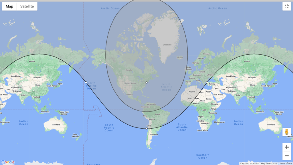
NYC 5km vs. 8km: The average maximum distances for New York City on FM and linear satellites. The inner circle (FM) shows what’s within 5,000km, while the outer band (linear) shows what’s within 8,000km.
The world—or a large part of it—is your oyster! Stations on the East Coast will have much greater access to Europe. With so many countries within the footprint of linear satellites, as well as a large portion of northwest Africa, your potential DX possibilities shoot through the roof. You also have access to a large portion of South America as well as every country in Central America and the Caribbean. Well over 150 DXCC entities are within the East Coast satellite operator’s grasp. Even FM-only satellite operators have access to most of Central America and the Caribbean, as well as a touch of South America. Some European Island DXCC entities like the Azores or the Canary Islands may be possible on FM, but the continent itself is just out of reach for the FM operator.
The only downside for the Right Coast? Hawaii is just outside the footprint for many east-coasters, making Worked All States impossible.
CHICAGO
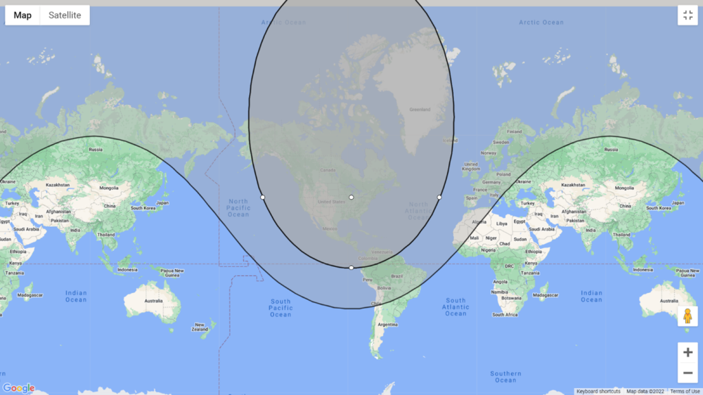
Chicago 5km vs. 8km: The difference between FM and linear satellite possibilities is evident in this coverage map of Chicago. Still plenty of DX to be worked from the Midwest.
While there’s less access to Europe and Africa than the East Coast, satellite operators in the Midwest get more access to a few DXCC entities in the Pacific to compensate, including Hawaii, Johnston Island KH3, Midway Island KH4, Palmyra and Jarvis Islands KH5, and Kure Island KH7. Asiatic Russia UA9 is also possible from Chicago.
Chicago has similar access to South America, Central America and the Caribbean as New York City, even for FM-only operators.
SAN FRANCISCO
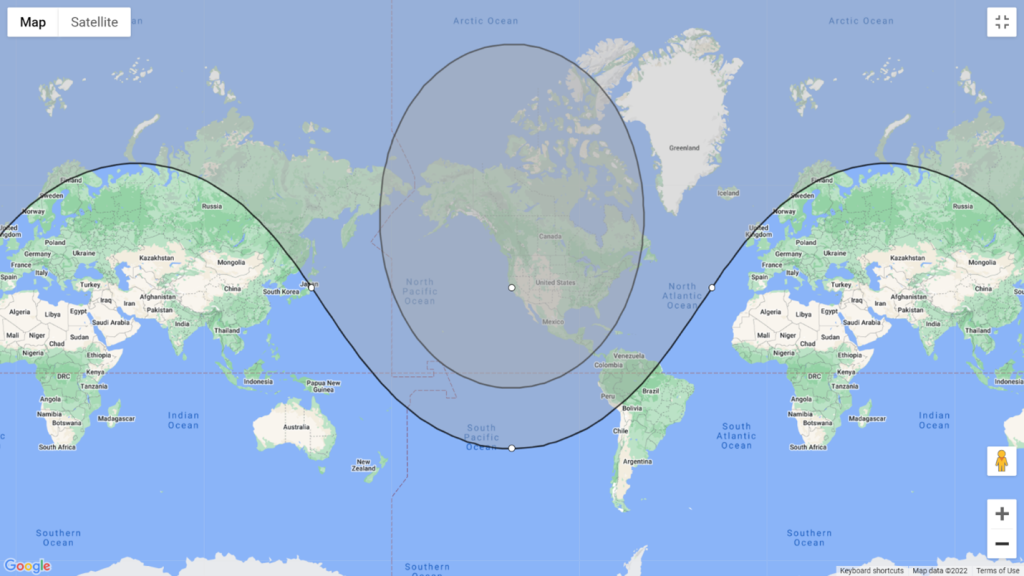
San Francisco 5km vs. 8km: FM vs. linear footprint coverage areas from San Francisco. While extra coverage of Asia and Oceania is very nice, it still doesn’t provide enough opportunities to work satellite DXCC from the West Coast.
Sadly, the West Coast has the fewest opportunities of DX via satellite than any other region of the U.S. While there is still full access to the Caribbean and Central America, Europe is just barely accessible on the linear birds, and only the northwest portion of South America can be accessed. The plus side is San Francisco can hit the northern portion of Japan, and entities in Oceania as far as Tuvalu, Tokelau, and American Samoa can be reached on the extreme ends of a linear pass. Unfortunately, there just aren’t as many entities in Oceania as there are in a similar sized territory in Europe, and under the current satellite environment, the chance of earning DXCC via satellite on the West Coast simply doesn’t exist mathematically.
Want to see what’s possible for your exact location? Visit mapdevelopers.com, punch in your address, and draw two circles (5,000km and 8,000km) centered on your location. You’ll be able to zoom in and see specific countries you will have access to.
Other Considerations
There is a big difference between “mathematically possible” and “workable.” Just because a lot of countries are mathematically possible to work on satellite and are within the footprint of your location doesn’t mean easy QSOs will be had. Satellite operating remains a niche activity of a niche hobby, and there are precious few satellite operators out there. Many entities that are common on the HF bands are quite rare on satellite, including many Caribbean nations.
Some satellite operators take gear with them when they travel internationally, creating opportunities to work some of these entities. In addition, AMSAT and other amateur radio organizations are actively trying to recruit new satellite operators worldwide. They are helping to spread the word to teams going on DXpeditions to take satellite gear. Many hams who go on an expedition during major contests, such as CQ World Wide or the ARRL DX Contests, have a great opportunity to serve the satellite community by taking satellite gear with them. More activity on the birds from DX entities is always welcome.
There have also been plans for China AMSAT (CAMSAT) to launch some satellites that will operate on 10 and 15 meters, similar to the Russian RS-12 satellite that was active in the early 1990s. The launch of these sats, CAS-5A and CAS-7A, have been delayed because of Covid, and the latest word is they will be launched in the fourth quarter of 2022. If they are launched relatively soon, better HF propagation due to the impending peak of Solar Cycle 25 will create the potential for DX paths on these satellites well beyond line of sight. This opens the door for HF operators worldwide to experiment with satellite operating using gear they already have. Stay tuned for news on this important launch!
Conclusions
Working DX on the satellites is conceptually no different than working it on the HF bands. Where you live has a part in determining how easy some entities will be to work, and there will be some that are easier than others. Just like in HF DXing, you will need to apply new skills and techniques to pursue the rarer and more difficult catches, but they are possible. There is no doubt that under the current low-earth orbit environment, DXCC on satellite is a formidable challenge, even for those on the East Coast of the United States. For those of us pursuing it, the hunt is just as enjoyable as the accomplishment.
Have a question about satellite operating? Email me (mailto: kx9x@yahoo.com) and I’ll be happy to help.