I’ve long been an advocate for operating on the Other Side of the Pileup. Taking your gear with you on vacation or a business trip gives you the opportunity to enjoy Ham radio from a new vantage point. If you seek out interesting places to transmit from, you can quickly become the rare station that everybody wants to contact. Who doesn’t like a little attention now and then?
Hams love collecting things: DXCC entities, states, counties, parks, islands. If it’s a piece of geography that can be defined, there are Hams trying to make contact with it. For the VHF+ and satellite communities, the geographic unit of choice is the grid square. These are “squares” of territory 2 degrees of longitude wide by 1 degree of latitude tall. Each grid square is roughly 60 x 120 miles. The actual size will vary; squares get smaller as you get close to the North or South Pole. There are 32,400 grid squares in the world, and 488 grid squares in the 48 contiguous United States. Grids are organized into clumps of 100 called a grid field. Grid fields are designated with a two-letter combination, and the 100 grids within a field are numbered 00 to 99. As an example, DX Engineering is located in eastern Ohio in grid square EN91. ARRL Headquarters is in grid FN31.
Why Rove?
The reasons people rove are numerous, but a lot of it comes down to a desire to not leave the radio behind when on the road. “Roving makes radio operations into a treasure hunt,” Bryan, KL7CN/W6, explained to me. “It is at once giving back, paying forward, and a fun adventure!”
Ken, VE3HLS, used roving to stay on the air in a Ham-challenged living situation, and ended up making a big discovery. “My interest in roving began a few days after I became active on satellites, because I lived in a townhouse complex that afforded a very limited view of the sky. I never once made a satellite QSO from my home QTH. Hams were interested even in the nearby grids I could activate and suddenly I discovered the biggest kick of my Ham career; I was DX! For me that was downright intoxicating!”
Ken activated over 70 grids in Ontario, Quebec, New Brunswick, and Nova Scotia between 2016 and 2018.
RJ, WY7AA, combines satellite roving with other family activities. “My wife wants to fly fish every stream in Wyoming. When we’re on the road for a fishing trip, I take the satellite gear with me, too.”
Jim, K5ND, saw how much fun other rovers were having and had to get in on the action. “I wanted to get out there and not only help out my fellow operators get rare grids in their log, but experience just a small portion of what they experienced on the other end of the pileup. It’s also great to get out into the wide open spaces and have fun.”
With 488 grids in the continental Unites States, many satellite operators aim to make contact with Hams in every single one. However, the Ham population interested in satellite operating in some of these grids is very small, or non-existent in a few cases. That means somebody has to travel to the rare ones to “activate” them, or put them on the air, just like an HF DXpedition to a rare DXCC entity. When most Hams hear the term “DXpedition,” they think of teams of a dozen or more, or chartering a boat with tons of gear to put that most-wanted counter on the air. Satellite operators do the same thing, only on a smaller scale. There’s the added bonus of being able to drive to most of the rare grids, as well.
Getting Started in Roving
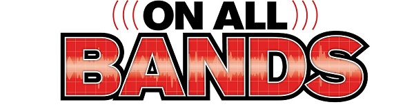
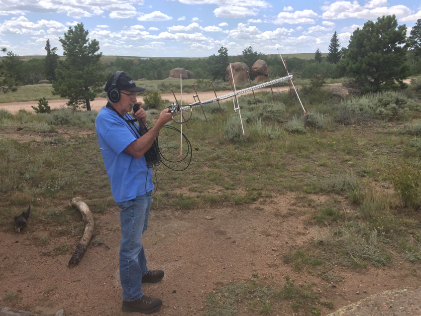
You don’t need a lot of gear to get started in satellite roving. Assuming you already know how to find and track the satellite, can hear yourself and can make QSOs, you already have the needed skills and equipment to do a rove. If you need help with the basics, check out my previous blogs on satellite operating. The most basic rove can be done with a dual-band HT and a dual-band, handheld Yagi. This can easily be thrown in the back seat. Any time you’re on the road, you’re roving.
For access to the linear satellites, you’ll need dual-band gear capable of SSB on 144 and 432 MHz. There and numerous rigs and combinations of rigs to accomplish this. Many portable satellite ops go for a configuration of two Yaesu 818s (or 817s), a couple of low-loss coax jumpers, a diplexer, headset, and a dual-band, handheld Yagi. Several lithium polymer batteries are available that are lightweight and can provide plenty of power to keep you running in the field. If you’re short on cash, the trusty sealed lead acid (SLA) battery can be had for next to nothing. Check with the IT manager where you work; odds are good they swap out SLAs from their backup power supplies, which keep the network up in case the power goes out. Many IT departments rotate those SLAs on a regular basis, and disposing of them properly can be tedious. They may gladly give you a couple of recent “pulls.” But be warned: While inexpensive and reliable, they weigh far more than lithium polymer batteries.
Where to Rove
The short answer to “where to rove” is any grid you don’t live in. Maybe you’re fortunate and live close to a grid intersection; you could drive to the next grid over, or pick your location carefully and operate from the grid line itself and give out two grids with one contact. Driving to visit relatives? Chances are you will pass through more than one grid square on the way.
Identifying grid boundaries is critical to roving. There are several mapping tools available. QRZ has a grid mapping tool on their site, or you could visit David Levine, K2DSL’s site, levinecentral.com, for a grid tool. There are apps, too—Maidenhead Converter and Hamsquare are just two available for iOS devices. Some GPS units offer location in Maidenhead grids, as well.
DX Grids
Of course, grid squares aren’t limited to the U.S. There are plenty of grids to activate worldwide, including Europe, the Caribbean, and Central and South America. Going on an international holiday? Taking satellite gear with you takes up far less space than an HF rig and antenna and still gives you that Ham radio fun factor. Just do your research to find out what the licensing requirements are for your destination. In some cases, no special permit is needed to operate from another country. ARRL’s International Operating pagecan help you find out what permits are needed to transmit from another country.
If you’re an active HF operator who operates in foreign locales for DX vacations or contests, please consider taking satellite gear with you. Some of those DX entities that are common on the HF bands are quite rare on satellite, especially in the Caribbean.
AMSAT keeps track of upcoming satellite grid activations on their Upcoming Satellite Operations page. Twitter is a great source for satellite info and operating tips; many serious satellite rovers tweet about their activity and operations in real time. Follow @AMSAT to get started.
Data Gathering—Finding the Rare Grids
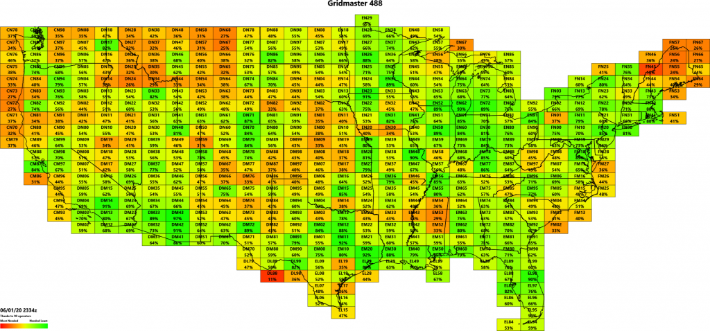
With all this talk of roving and collecting grids, you would think somebody would take the time to come up with a way to track that information. You would think correctly. Robert Bankston Jr., KE4AL, created a simple Excel spreadsheet to keep track of the grid squares he worked via satellite, which grids were worked vs. confirmed, and who he contacted in that grid. Improvements and adaptations by Tanner Jones, W9TWJ, and Chris Tabor, K7TAB, have made the spreadsheet a powerful and visually appealing tool to track your progress toward working all 488 grids in the U.S.
Paul Overn, KE0PBR, realized that active satellite operators were using this tool, and the collective data from those maps would give a reasonably accurate assessment of which grids were still needed by most satellite operators. He developed the Gridmaster Heat Mapusing crowdsourced data from satellite operators on the KE4AL spreadsheet. Paul posts regular updates to the Heat Map on his Twitter feed and encourages people to share their data; follow @GridmasterHeat on Twitter to see this data.
Knowing which grids are rare can help you plan your roving adventure. While any grid is fair game, you might be surprised just how close you are to a truly rare grid square.
Recognition
While handing out grid squares on your rove will earn you the respect and adoration of your fellow satellite buffs, it’s nice to get recognized for your achievement. AMSAT offers the Rover Awardfor Hams who activate grids other than their home grid. Follow the link for more information.
Conclusion
No matter how you slice it, portable Ham radio is fun. With a little investment, you could be taking Ham radio with you and become the sought-after station via satellite. Drop me a line [mailto: kx9x@yahoo.com] if I can help with any questions about satellite operating or roving. Here’s to working you from a new grid!