
OnAllBands is nearing the end of our review of the top-ten Most Wanted DXCC Entities—and what a long, strange trip it’s been.
How long? We decided to find out.
For the fun of it, we’ve calculated the distance you’d have to travel to reach each entity—one through nine in order on the list. Assuming you had unlimited time and resources plus permission to land on each entity (North Korea, Scarborough Reef, San Felix Islands, Pratas Island, Kure Island, Johnston Island, Peter I Island, Kerguelen Island, and today’s spotlight locale, Aves Island), can you guess how many miles you’d have to travel starting in North Korea, sailing to Scarborough Reef, then to San Felix Island, etc.?
You’ll find the answer at the end.
Aves Island (YV0)
Aves Island, or Isla de Aves (Spanish for “Island of Birds”), is a Federal Dependency of Venezuela in the Caribbean Sea that ranked as the ninth Most Wanted DXCC Entity per Clublog as of June 2025.
This tiny island in the Leeward Antilles is one of the smallest of all 340 DXCC entities—just slightly larger in area than Saint Peter and Paul Rocks (PY0S), ranked #14. The island measures 1,234 feet long (equivalent to the height of a 100-story building) and 160 feet wide (the width of an American football field). It becomes completely submerged during hurricanes, making it a notorious site for shipwrecks. When the weather is calm, the island can rise about 13 feet above sea level.
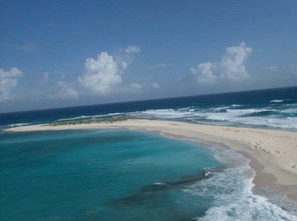
Aves Island is 140 miles west of Dominica, 115 miles south-west of Montserrat, and 340 miles north of Venezuela’s mainland. The sand-covered island is a nesting site for green turtles and home to a variety of seabirds. Its population of brown noddies and sooty terns has earned it the designation as an Important Bird Area by BirdLife International.
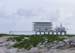
In June 1978, the Venezuelan Navy constructed the Simón Bolívar scientific Naval base on the island. Built on stilts, the site is permanently inhabited by scientists and Navy personnel.
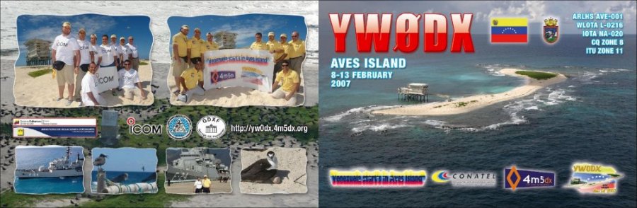
Aves Island was added to the DXCC list in 1956. It has been activated sporadically since then. The February 2007 YW0DX DXpedition (22,000 QSOs over 70 hours of operating) was the last time it was on the air. See photos from YW0DX here.
A planned 10-day activation of Aves Island in commemoration of Navy Day 2016 by the Amateur Radio Association of Venezuela, Santiago de Leon de Caracas Group was scuttled by the Venezuelan Navy. The activation was put “on hold until further notice” for reasons outside of the DXpedition team’s control,” per a release from the DXpeditioners, who were set to depart for the island. Nine years later, operators and chasers are still waiting for the next chance at Aves Island. As DXers have noted, even Rig in a Box (RIB) ventures can’t overcome the hurdle of military restrictions.
Despite the paucity of opportunities, the avid DXers at DX Engineering have managed to make contact with a number of Aves Island DXpeditions over the years. Here are a few of their QSL cards:
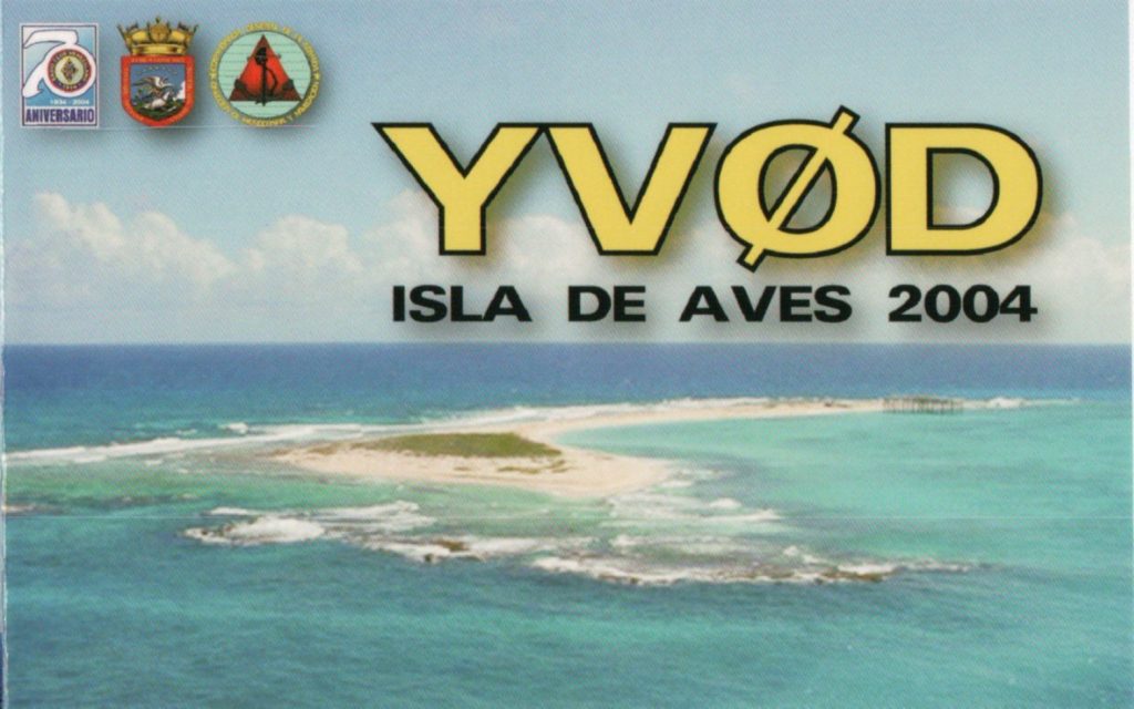
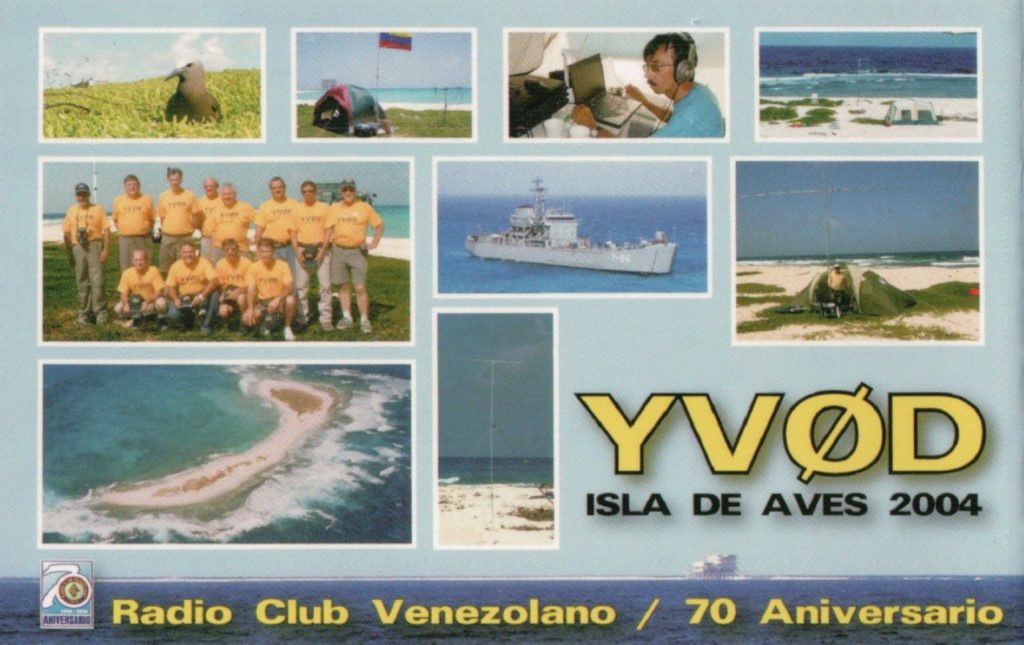
Tom, KB8UUZ, DX Engineering technical writer, reached YV0D in August 2004. The DXpedition logged 18,500 QSOs before being shut down due to impending storms that could have buried the island in sea water.
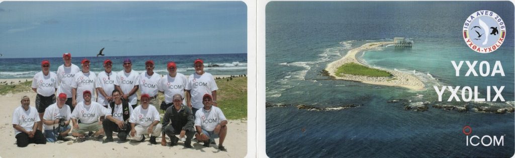
George, K3GP, DX Engineering customer/technical support specialist, received this QSL card from the YX0A/YX0LIX 2006 Aves Island nine-day DXpedition in April 2006. Tragically, Jose “Joe” Rodriguez, YV5LIX, died of a heart attack on the island at the age of 57. He is memorialized on the back of the card and with the special call the team secured after the DXpedition.

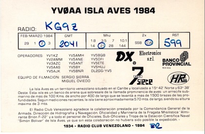
Scotty, KG9Z, DX Engineering customer/technical support specialist, reached the YV0AA DXpedition in March 1984. Many older Aves Island activations used the YV0AA call sign.

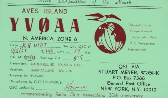
Wayne, K8FF, DX Engineering customer/technical support specialist, earned this QSL card as K8WOT in 1963.
Long Strange Trip Answer
So, how many miles would you have to travel to reach the top-nine DXCC entities in order? Per our calculations—and help from Google—the final figure is 54,005 miles, enough to circumnavigate the globe twice—with some miles to spare.
Check out these OnAllBands articles on the current top-eight most-wanted entities:
- Kerguelen Island
- Peter I Island
- Johnston Island
- Pratas Island and Kure Island
- North Korea, Scarborough Reef, and San Felix Islands
What’s left on the top-ten list? We’ll be rounding out our coverage with recently added Turkmenistan, which climbed into the top ten ahead of Bouvet Island. Stay tuned!
In the meantime, visit DXEngineering.com for everything you need to upgrade your station to make sure you’re ready when entities like Aves Island are in play. You’ll find transceivers, antennas, amplifiers, CW keys and paddles, headsets and speakers, reference books like “Ham Radio DX: A Complete Guide,” and much more.
***
Editor’s Note: Every month, DX Engineering features QSL cards from our team members’ personal collections. To highlight upcoming DXpeditions, we’ll be displaying a few of our favorite cards along with details about what it took to make these contacts. We’re excited to share some of the special cards pulled from the thousands we’ve received over the years. We look forward to seeing your cards as well!